Back to Stensjön
With the leaves turning yellow and red, and with the sunny days being fewer and farther between, I thought I'd sieze the opportunity when it came in the form of a sunny Tuesday and do a late summer return to Stensjön.

2011-10-04 12:59

2011-10-04 13:02

2011-10-04 13:18

2011-10-04 13:19

2011-10-04 13:26

2011-10-04 14:02

2011-10-04 14:11

2011-10-04 14:26
2011-10-04 14:40

2011-10-04 14:59

2011-10-04 15:08

2011-10-04 15:21
2011-10-04 15:59

2011-10-04 16:01

2011-10-04 16:25

2011-10-04 16:56

2011-10-04 17:05

2011-10-04 18:17
The Hike
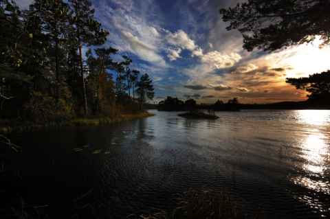
There's an easy and a hard way to Stensjön. The easy way is for people with cars, who can drive all the way to the lake.[1] The hard way is for the rest of us, and entails a hike from Tyresta By across pretty much the whole park, until finally reaching Stensjön. Unlike last time, the water levels were normal and I had no problem getting all the way to Stensjön without involuntarily wading.
I had two goals for this hike: Shoot a forest panorama, and get a shot of the two small islands in Stensjön.
Forest Panorama

2011-10-04 13:51
The purpose of the forest panorama was to have a photo of nothing much in particular - just compact forest, with no trails or other interruptions. I wanted it to be as close to a representative sample of one of the kind of forest that you find in Tyresta. It also had to be pretty to look at. I finally found this spot that satisfied both requirements.
I shot the panorama hand-held using a Sigma 10-20mm lens. I used 20mm for the horizon, and switched to 10mm for the top and bottom. While shooting hand-held always means more work when stitching, this time it turned out to be a nightmare. While the forest floor worked out all right - more or less, but who will ever see the difference - the part with tree trunks silhouetted against the bright sky turned out to be a lot more difficult. If the details on the forest floor won't line up properly, the image blending will take care of it. There is so much visual noise in the region that the seam line can be hidden well. But the trunks provided a challenge: A straight tree trunk that suddenly veers off in another direction, or one where the trunk abruptly shifts to one side; those are elements that jump out at the viewer.
The panorama was finished with a couple of hours in Photoshop. Patches were copied, stretched and distorted to cover up the stitching errors. Would a panoramic tripod head have made it easier? Undoubtedly. But the tops of the trees were swaying in the wind, so even if I had carried my Nodal Ninja Mk. III it would have come down to 'shopping.
Stensjön Islands

2011-10-04 15:42
I'm particularly happy about finding this spot. On Tyresta's homepage there is a photo from (I suspect) here, showing the two islands that can be seen in the panorama, and I had always wondered where it was taken from but never been able figured it out until now. In this area there are some fairly steep cliffs leading into the water, which made it a good place for set up a hill fort; something the locals did a long time ago in order to have a place to retreat to in times of unrest. I don't know when the fort remnants date from, but it was listed by the government of Sweden in 1668 and is listed as Tyresö 106:1 / Stensjöborg[a].
The fort covers two hilltops - an eastern and a western - with a narrow notch between them. On each side of the notch the hills, which are basically two big, bare rocks, rise near vertically. It is not difficult to imagine that an attacker would have to fight very hard to successfully assault anyone defending the fort. It was this notch that confused me last time. The western hilltop is slightly lower than the eastern, and the line of sight to the water is obscured by trees. I tried to find a spot where I could see the islands from when I was here the first time. No luck. Moving towards the notch I was faced with a steep rock face, which made me conclude that there was no success to be had in that direction. This time, however, I went north and found a place where one could climb up on the eastern hilltop by following the remnants of the defensive wall up the hill.
Success!
As the tracklog shows, it is possible to descend the hilltop to the east. One has to zig-zag among sharp drops and leftovers of walls, but it can be done.