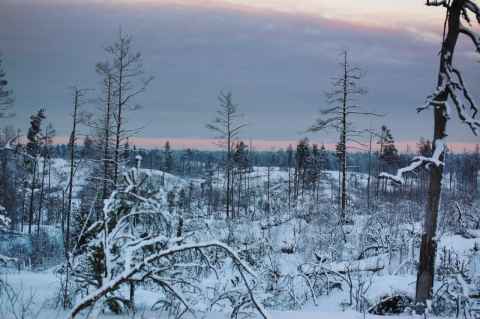
Burnt Area, Tyresta
A massive forest fire devastated 4.5 square kilometers of the park in 1999. The area can still be seen on the map as a gray patch surrounding Stensjön, and from the ground it is very noticeable as the can be seen in the photos below. When I started this hike my goal was to get to Stensjön by hiking past Bylsjön and then going more or less straight across the burnt area from there (see below), but I turned around about two kilometers away from Stensjön.
Besides going to Stensjön, I had as a goal to shoot some VR panoramas. If possible, I would try to do VR panoramas with my Raynox DCR-250. I thought I would be cool to place the viewer at ground level and show the world as seen by a beetle.

2011-01-14 12:33
Getting close-up shots with a wide-angle lens is hard. On one hand, they have very small close focus distances, but on the other hand their wide field of view tend to make anything in the image center disappear in a pinched-up point. They also have great depth of field, which puts more or less everything in focus. This was an experiment to see if I could get a reasonable separation of fore- and background by using the lens wide open, and get a reasonable framing of a small foreground object (the twig in this case). The biggest difficulty was to find the close focus distance of the lens. I ended up putting the center focus point on the twig, holding down the shutter release, and then slowly moving the camera away. The camera would then release the shutter as soon as the twig was in focus - a kind of faked focus-priority release.

2011-01-14 13:18
This was the first VR panorama I shot. It turned into a nightmare, but fortunately the shooting conditions were fairly constant. In an attempt at getting the tripod out of the image as much as possible, I set it up with the feet in a very small triangle. Combined with uneven ground hidden beneath the snow, a lot of fumbling by me, and a desire to not disturb the snow I ended up bumping the tripod a lot. I also managed to forget at least one step in my list every time I tried to get it right. Persistence pays off, though, and once done I was a lot more prepared for the next two shots.

2011-01-14 14:01
This is the third panorama I shot (the second didn't turn out as well, with a lot less interesting sky). Like the first and second, there was a lot of fumbling and stress. This time it wasn't as much caused by forgetting things - it was related to the rapidly changing conditions. In the panorama you can find the sun, a bunch of clouds and the burnt area. I wanted to get them all properly placed and exposed in the image. This meant I had to find the right time where the sun lit up the clouds the way I wanted, and where I could get an exposure that would capture both the view toward the sun and out toward the burnt area without losing shadow or highlight detail. Of course, once perfect shooting conditions appeared, I had to get my 24 shots[a] done before they disappeared.
I briefly toyed with the idea of shooting the panorama in priority order. That is, get the most important shots done first, then fill in the rest. I then realized that if the conditions changed between the high-priority shots and the low-priority shots, I'd be without a panorama no matter the order, as they would be a nightmare to assemble. It was therefore to my advantage to just stick to the routine - get all the 24 shots as fast as possible.

2011-01-14 14:50
The final panorama. By now I had gotten the actual shooting down to routine. I also decided to get the moon into the panorama, as it was visible since the clouds had moved away. The challenges were to find the right spot where the moon was seen, find the right exposure and shoot at the right time. Add to that the fact that the moon is moving and disappears behind a tree every now and then and you get a couple of variables to juggle. I was also worrying about the nadir image. In my attempts are finding the best position I had moved the tripod around and left a lot of footsteps in the previously undisturbed snow. Getting them out of the panorama would be quite a task. I also had to switch to a timed remote release, as the camera was wobbling a little bit every time I rotated it to a new position. This added two seconds to each shot, or almost a minute in total.
This was the first panorama I assembled when I got back home, and just as with the shooting, the first time I couldn't get anything right. I mis-aligned the photos, got bad zenith and nadir images, and so on. I think it took something on the order of eight hours to get the editing done. By the end I had a 1.2GB PSD file that took a couple of minutes to save, and my computer was swapping all the time. I considered including "a book to read" in my list of equipment for VR panoramas - it'll keep you from boredom while you wait for the computer to do something.
2011-01-14 15:01
The opposite of the VR panorama. A shot taken with a tele lens of the burnt area. It captures the lack of vegetation, but not the general desolation as well as the panorama. On the upside, it was a lot easier to get done. Hand-held and maybe three or four minutes of post-processing was all that was needed.
The Hike
The original plan was to go to Stensjön, and as the map shows, the plan was to follow Bylsjöslingan until it turns south and returns to Tyresta By. The plan worked great up until I rounded the top of Bylsjön. The snow, that so far had been a thin layer on the trail, started to become really thick. Never mind, three or four inches of snow is not a problem, I thought, and went on.
It was when I reached the point where the trail to Stensjön branches off that I realized that going to Stensjön was going to be quite a bit harder than I had originally assumed. The trail was covered in thick snow, maybe eight to ten inches. That in itself was just a nuisance. The problem was below the snow. The preceding days had been the first warm days in a few months, and a lot of the snow had melted. Then the temperature had dropped again just the day before I arrived here. The result was that below the layer of snow was ice, and below the ice, water. Not everywhere, but everywhere you'd normally find puddles of water.
Sinking through the snow down to your knee, and hearing the unmistakable sound of your boot going through ice and underwater, was what made me reconsider. Getting tired and exhausted from going through knee-deep snow? Sure. Can do. End up with soaked feet, hours away from someplace warm? No.
Just for the hell of it I followed the trail to the edge of the burnt area. As you can see in the photos, even eleven years on, the landscape is very much marked by the fire.
Links
https://monochrome.sutic.nu/2011/01/16/making-vr-panoramas.html#the-equator |